Western Sydney is transforming to meet the needs of a growing and changing population. The NSW Government is helping plan new communities and infrastructure in the Greater Penrith to Eastern Creek area.
Together with Penrith City Council, Blacktown City Council and state agencies, we are planning for new homes and jobs growth close to transport, schools and public spaces.
To make sure the growth is sustainable and builds on the investment and benefits of the Sydney Metro – Western Sydney Airport Line and Western Sydney Airport, we have prepared the Greater Penrith to Eastern Creek Strategic Framework. The framework was finalised in June 2023.
A strategic growth area
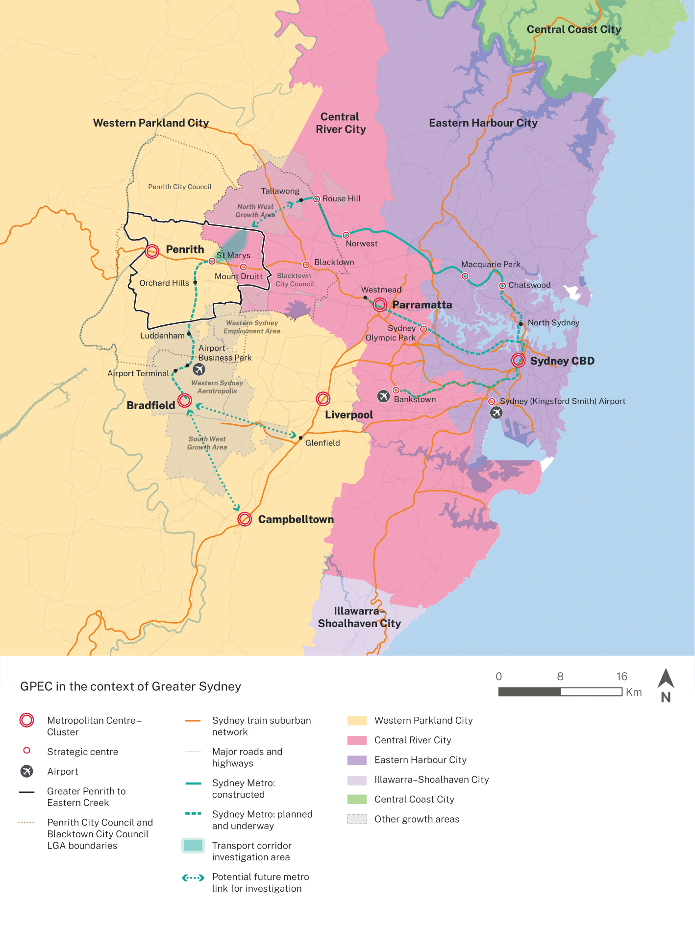
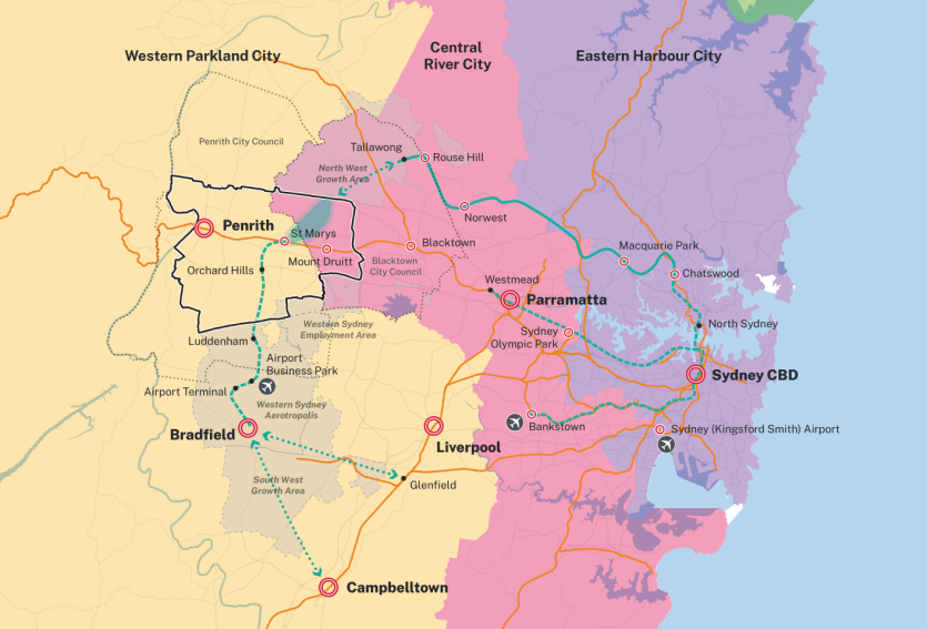
The Greater Penrith to Eastern Creek area was identified as a potential area for growth in the Greater Cities Commission’s Western City District Plan and the Central City District Plan.
The area covers about 19,000 ha. It extends from the Nepean (Dyarubbin) River in the west to the M7 Motorway in the east. It links the North West Growth Area with the Western Sydney Aerotropolis.
Development of a strategic framework for the Greater Penrith to Eastern Creek area supports delivery of The Greater Sydney Region Plan – A Metropolis of Three Cities, a vision for most people to live within 30 minutes of their jobs, schools, healthcare and great places.
The strategic framework delivers on the NSW Government commitment in the Western Sydney City Deal to progress planning in the area. The strategic framework makes sure new homes can be planned and delivered alongside new infrastructure such as schools, health care and transport.
What has already happened
We released the draft Greater Penrith to Eastern Creek Strategic Framework for feedback between 18 November and 16 December 2022. We considered all the feedback provided and used it to create the final strategic framework.
You can find more information on the Greater Penrith to Eastern Creek Strategic Framework on the NSW Planning Portal.
What happens next
The strategic framework will now be used to support planning and growth in the Greater Penrith to Eastern Creek area.
We have identified Orchard Hills as a priority urban release area within the strategic framework and begun a precinct planning process.
For more information, go to the Orchard Hills precinct page.
Penrith City Council is continuing to plan for the St Marys town centre, which is also identified as a priority area in the strategic framework.
For more information about St Marys, go to Penrith City Council.
Frequently asked questions
The GPEC Strategic Framework (the framework) is a strategic planning document that will guide future detailed planning for the area. It consolidates and builds upon the strategic planning and infrastructure work already undertaken in the area to set a clear direction for future growth and development.
The framework sets out:
- a vision for growth,
- planning priorities to deliver the vision,
- directions and actions to implement each of the planning priorities; and
- infrastructure that may be required at the regional and district level to support growth.
The framework has been prepared to support strategic planning for the Western Parkland City. It outlines a clear vision for GPEC, together with a framework of priorities and actions to guide future precinct planning and development.
It also supports local planning to achieve a shared vision for the GPEC area, by providing guidance for precinct planning and planning proposals, and informing new or revised local planning controls like Local Environmental Plans (LEPs) or Development Control Plans (DCPs). The framework and supporting documents identify:
- special features and characteristics of the area that are valued by the community,
- a spatial framework that includes:
- locations to focus new development and supporting investment to enable growth and innovation.
- areas of limited or no change; and
- places to be retained for open space or environmental purposes.
The framework identifies St Marys Town Centre and Orchard Hills Investigation Area as priority precincts. This means that these areas will be planned for in the short-term to leverage the potential for growth and investment arising from the Sydney Metro Western Sydney Airport line.
Penrith Centre, Kingswood and Werrington and Mount Druitt and Rooty Hill are identified as short-term renewal areas, where there is potential for growth aligned with the strategic role outlined in the framework. For example, Kingswood and Werrington will become a health and education precinct to support the continued economic growth of The Quarter and the east-west economic corridor.
The framework does not prevent development in areas that have not been identified as focus precincts. We expect limited change in these areas as they are largely established precincts. Any proposed land use change is anticipated to be through proponent or council led planning proposals which will be subject to an assessment of strategic and site specific merit.
The Strategic Framework does not rezone land in GPEC. It identifies areas that will need further detailed planning and provides a framework to guide the planning process that would lead to future rezoning in these areas. The more detailed planning could be led by Penrith City Council, as is occurring for St Marys, or by the department, as is occurring in Orchard Hills.
The framework is a strategic planning document intended to guide the more detailed planning of the area, and it does not identify land for acquisition. Further detailed planning is needed to identify land that may be needed for housing and employment, as well as future infrastructure such as roads, open space and schools. Any plans that propose land for public use, and possible acquisition, will be publicly exhibited and involve consultation with affected land owners.
The 2022 NSW Flood Inquiry made 28 recommendations in response to the 2022 floods; 10 of these related to land use planning. The inquiry noted opportunities to improve and strengthen proactive flood planning, including resetting flood planning levels using a catchment-specific, risk-based approach. The inquiry identified high risk catchments, which included the Hawkesbury-Nepean Valley. GPEC is located in the Hawkesbury-Nepean Valley.
The inquiry recommended adopting a new risk-based approach to calculating flood planning levels. This work is to be undertaken by the NSW Reconstruction Authority with the inquiry recommending that the modelling for high-risk catchments, such as the Hawkesbury-Nepean Valley, be completed in 3 years. Implementing this recommendation will likely result in different flood planning levels across catchments and it is expected that higher risk catchments will move to a higher flood planning level.
Until the new flood levels are established, the department is adopting a risk-based approach to the assessment of planning proposals and development applications, considering the risk relating to the type of development proposed and the flood risk specific to its location.
The final Strategic Framework commits the department to ongoing collaboration with agencies to implement recommendations of the NSW Flood Enquiry and recommends that development be located in areas that minimise risk, reflecting the move to a risk-based approach to the assessment of development proposals.
The Cumberland Plain Conservation Plan (CPCP) supports growth and biodiversity conservation in Western Sydney by identifying land that is capable of urban development and land that should be protected for biodiversity reasons. The CPCP will contribute to the Western Parkland City by supporting the delivery of housing, jobs and infrastructure while protecting important biodiversity including threatened plants and animals.
The CPCP aims to streamline the development process by providing strategic biodiversity certification under the NSW Biodiversity Conservation Act 2016. It will, if approved by the Commonwealth, provide a strategic assessment under the Commonwealth Environment Protection and Biodiversity Conservation Act 1999, meaning no further biodiversity approvals are needed in certified areas in the Greater Macarthur, Aerotropolis and Wilton growth areas and the Greater Penrith to Eastern Creek investigation area.
The framework has used the NSW Population Projections released in August 2022 to estimate the growth in population and dwellings in GPEC to 2056. Consequently, these projections differ from those contained in Penrith and Blacktown City Councils’ Local Strategic Planning Statements, as these documents were prepared in 2020 using earlier population projection data.
The department also undertook a detailed comparison of Local Housing Strategy data from both council areas and the 2022 department growth projections to 2036 that are included in the Strategic Framework. This analysis found that there is broad alignment across these numbers as well as across the definition of how these areas have been mapped. The main differences are that Penrith Council projects a higher population in St Marys by 2036, and a lower number in Orchard Hills by 2036, compared to the 2022 department population projections that are incorporated into the Strategic Framework.
The projected jobs growth figures in the framework have been informed by technical expert advice and recent changes in growth patterns resulting from the COVID-19 pandemic.
The framework will inform ongoing strategic planning by the councils, including local strategies and future updates to local strategic planning statements (LSPSs).
The framework identifies infrastructure that may be needed to support growth. Funding for infrastructure in short term renewal areas will be through a variety of sources including state and local infrastructure contributions, voluntary planning agreements and Government grants or direct funding from state or local governments.
The final Strategic Framework has been informed by submissions received on the draft Strategic Framework, which was exhibited in November and December 2022. The details of changes that were made as a result of feedback can be found in the finalisation report on the NSW Planning Portal.
The framework has now been finalised.
The department will continue to collaborate with the community, key state agencies and Penrith and Blacktown City Councils to implement the framework, and work towards the vision for GPEC and the broader Western Parkland City.