What’s happening now
Woy Woy Road, Kariong planning proposal
We received a planning proposal from the Darkinjung LALC for a site on Woy Woy Road, Kariong (the proposal) in June 2020.
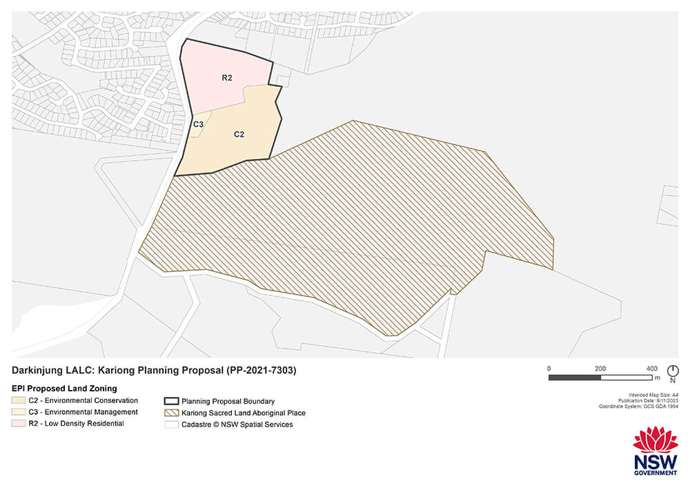
The proposal seeks to rezone land to deliver up to 50 dwellings in a community title scheme and create a pocket park to protect an identified Aboriginal cultural heritage site within the development site. Read more about the Darkinjung LALC’s Woy Woy Road, Kariong Planning Proposal.
Council was offered the role of planning proposal authority (PPA), to prepare the proposal for gateway determination by the department. Council declined this role and the Hunter and Central Coast Strategic Planning Panel (the panel) appointed itself to the PPA role.
A Gateway determination was granted on 21 May 2021. The Gateway determination allowed the proposal to proceed to public exhibition, subject to conditions being met.
The proposal includes detailed supporting studies that respond to consultation with state agencies and entities that was a requirement of the Gateway determination.
Darkinjung LALC updated the planning proposal in the first half of 2023 to respond to comments received from state agencies and entities and to incorporate the findings of additional supporting studies.
We have assessed the updated planning proposal and determined that it satisfies all gateway conditions.
The exhibition for the Woy Woy Road, Kariong planning proposal has now closed.
The planning proposal was open for public feedback from 1 December 2023 to 29 January 2024.
Next steps
Woy Woy Road, Kariong
A review of all public submissions will be undertaken. All submissions received throughout the exhibition period will be reviewed and considered in the assessment of the proposal.
A planning report will also be prepared which will include recommendations to the panel about the future of the planning proposal in response to community feedback.
The panel will then make a recommendation to the department on whether the proposal should be finalised and, if so, in what form. The minister, or the department as the minister’s delegate, will make the final determination for the planning proposal.
What has happened
The Darkinjung Development Delivery Plan (PDF, 12.2 MB) was approved by the Minister for Planning on 16 December 2022 under the provisions of Chapter 3 Aboriginal land of the State Environmental Planning Policy (Planning Systems) 2021.
The delivery plan applies to 31 sites (consisting of 94 lots) in the Central Coast local government area. It considers the high-level opportunities and constraints associated with future development of the 31 sites. It supersedes the interim DDP from 2019 and is underpinned by a strategic assessment which considered the land-use potential of all Darkinjung LALC land holdings in the Central Coast LGA.
The DDP does not approve development on the sites. The approval of the DDP was the first step toward consideration of planning proposals or development applications, with further community consultation to be conducted.
The DDP allows planning proposals for the sites to be independently reviewed by the Hunter and Central Coast Strategic Planning Panel (the panel).
The DDP responds to the Aboriginal Land Rights Act 1983, which established Aboriginal land councils to manage land to provide an economic base for Aboriginal communities as compensation for historic dispossession and ongoing disadvantage.
The DDP will help Aboriginal people develop their land to support their community and protect Aboriginal cultural heritage. It will also provide new homes and jobs for the wider community.
We will continue to work with the Darkinjung LALC and consult with Central Coast Council on planning for the DDP sites.
More information
- Read more about the proposal at the NSW Planning Portal
- For questions regarding the submission process, email the Central Coast team at [email protected]
- For more information on the gateway determination process, go to Making and amending LEPs
Frequently asked questions
The Darkinjung Local Aboriginal Land Council is an incorporated body constituted under the NSW Aboriginal Land Rights Act 1983. Its objectives are to improve, protect and foster the best interests of all Aboriginal people within the land council’s area and other people who are members of the land council.
The Darkinjung Local Aboriginal Land Council mainly covers the Central Coast, with boundaries stretching from Catherine Hill Bay in the north, Hawkesbury River in the south, the Pacific Ocean in the east and Watagan mountains in the west.
The land was granted to the land council under the provisions made in the Aboriginal Land Rights Act 1983 to compensate Aboriginal people for the historic dispossession of land, and in recognition of their ongoing disadvantage.
Land councils are charitable statutory bodies corporate, whereby all of the financial proceeds of a land council’s operations must be reinvested into improving, protecting and fostering the best interests of all Aboriginal persons within the land council’s area.
No. The planning proposal intends to amend the Central Coast Local Environmental Plan 2022 to rezone 5.7 hectares of the site to R2 Low Density Residential. If the planning proposal proceeds, it will enable the land council to submit a development application for subdivision, which would allow up to 50 dwellings. Any proposal to construct a dwelling will also need development consent.
Any future development application would be subject to further assessment, including consultation that would consider environmental, social and economic matters under the NSW Environmental Planning and Assessment Act 1979.
Most of the remainder of the site, consisting of 7.1 hectares, will be retained for environmental conservation and provide a buffer between the proposed residential zone and Brisbane Water National Park.
The proposal is not developing Kariong Sacred Lands, which is defined under the National Parks and Wildlife Act 1974, and will not have an impact on this land. The site adjoins, but is not part of, Brisbane Water National Park, which contains the Bulgandry Art Site Aboriginal Place to the south-west and Kariong Sacred Lands to the south (refer to Figure 1).
The site’s land use zone has changed over time. The site was previously zoned under the now repealed Gosford Planning Scheme Ordinance as 5(a) Special Uses and had been considered as a potential site for a school.
The zone was changed to C2 Environmental Conservation with the making of the former Gosford Local Environmental Plan 2014. This zoning has continued under the current Central Coast Local Environmental Plan 2022.
The Environmental Planning and Assessment Act 1979 provides for amendments to planning controls or mapping in existing Local Environmental Plans via a planning proposal.
The Department’s Local Environmental Plan (LEP) Making Guideline requires planning proposals to demonstrate strategic and site-specific merit to determine whether a proposal should be supported.
Any planning proposal seeking to rezone land zoned C2 must demonstrate the proposal aligns with the NSW strategic planning framework. It must also identify the potential environmental, social and economic impacts of the proposal and outline proposed mitigation measures and justification.
A proposal that impacts biodiversity must demonstrate that any issues are addressed via an assessment undertaken in line with state biodiversity legislation and in consultation with the Department’s Biodiversity and Conservation Division. It must also align with biodiversity-related strategies set out in the Central Coast Regional Plan 2041.
No. An Aboriginal cultural heritage report was prepared to assess the potential impacts of future development. The land council has taken all possible measures to protect Aboriginal cultural heritage, with 12 registered Aboriginal parties being consulted.
The proposed residential zoning avoids impacts on known items of Aboriginal cultural heritage, except for one. Due to its location and being rock engravings, the land council is proposing to preserve this item within a local park should the proposal proceed to the development application stage.
An Aboriginal cultural heritage report was prepared for the site which made recommendations to protect known sites, including barrier fencing during construction, and the creation of a pocket park with a 20m buffer surrounding sites. Ground-truthing of known sites rectified issues with the accuracy of some site locations.
The cultural heritage report was independently reviewed by Heritage NSW, which expressed support for the proposed conservation areas that encompass most recorded sites.
No. The land council commissioned an independent biodiversity certification assessment report to determine the impact of proposed development on the site, including surveys for koalas. The species was not detected.
The Kariong site is identified as an area of regional koala significance on the NSW Government’s SEED database. The SEED database identifies large areas of the Central Coast that have existing urban development as areas of regional koala significance, including the surrounding residential areas of Kariong, West Gosford, Point Clare, Tascott and Koolewong. The koala mapping is indicative only and highlights large areas of the state where further site-specific analysis is necessary to identify koala habitat and the presence of koalas.
The NSW Biodiversity Conservation Act 2016 establishes a scheme for the biodiversity certification of land. A biodiversity certification assessment report has been completed for the proposal, which will deliver a biodiversity offset strategy that appropriately compensates any loss of biodiversity values because of the proposal.
Our Biodiversity and Conservation division reviewed the proposal and biodiversity assessment report and notes the intent to undertake further assessment and biodiversity certification to enable development in areas identified as habitat for serious and irreversible impact species. The Biodiversity and Conservation division supports the implementation of a biodiversity offset strategy.
No, the rezoning will not harm the wetlands that have been identified on the site. These are in the area proposed to be zoned C3 Conservation Management to the south-west of the proposed R2 Low Density Residential zone. The land council propose to retain these wetlands for urban stormwater detention. Any future development application for work within the C3 Environmental Management zone will need to consider the impact of development on the wetlands.
This is a planning proposal to rezone the land only and does not grant consent for physical works on site.
Darkinjung Local Aboriginal Land Council is committed to protecting the environment and contributing to the wellbeing of the land and the community.
Any further development, such as tree removal or earthworks (cut or fill), will need council approval via a development application process. Central Coast Council has clear guidelines on cut and fill and tree and vegetation removal in the area covered by the Central Coast Development Control Plan 2022. See also, 'Will developers be able to remove native vegetation?'
Most of the Central Coast LGA is identified as ‘bushfire prone land’ and this mapping identifies where further detailed assessment is required. The site is identified on the bushfire prone land mapping as ‘Vegetation Category 1’ and ‘Vegetation Buffer’.
A strategic bushfire study prepared for the site concluded that the proposal can comply with the relevant specifications and requirements of Planning for Bush Fire Protection 2019.
The study identifies the primary emergency evacuation route onto Woy Woy Road and an option for a secondary route onto Jeniwa Close, subject to detailed design at the development application stage.
The study concluded that the proposed development, in combination with future bushfire protection measures, will not create areas that are difficult to evacuate, or place existing residents in Kariong at increased risk.
The NSW Rural Fire Service have been consulted at pre- and post-Gateway stages and raise no objection to the planning proposal. We will continue to consult with the NSW Rural Fire Service during the public exhibition period and report on the outcome.
The application has been made by the land council as the owner of this site. This assessment is to review the proposal and its effect on the site proposed. Consideration of alternative sites is not a planning matter. Irrespective of who the landowner is, or how much land the landowner owns, each application is assessed on its site-specific merit and strategic merit.
Some members of the community have suggested that the entire site should become a national park and alternative compensation be given by the government to the Darkinjung Aboriginal Land Council.
NSW Government has been clear that there is no opportunity for alternative compensation in the current fiscal environment. It is important to acknowledge that land rights aren’t about reclaiming land to add to the public estate. Land rights are about prioritising self-determination, which is a goal attainable only with access to economic resources.
Preliminary consultation with National Parks and Wildlife Service took place as a condition of the Gateway determination. This led the land council to consider incorporating the proposed C2 Environmental Conservation zone area of the site within the adjoining national park. We will consult further with National Parks and Wildlife Service during the public exhibition period and report on the outcome.
The community can give its feedback on the proposal through the public exhibition period, which is a requirement of the Gateway determination under section 3.34(2)(c) and schedule 1 clause 4 of the NSW Environmental Planning and Assessment Act 1979.
All submissions will be reviewed, with the proponent having the opportunity to respond to the planning proposal authority on any issues raised. The Hunter and Central Coast Regional Planning Panel is the planning proposal authority. The panel reviews the planning proposal following public exhibition and addresses any community, agency or other objections and responses by the proponent.
If the planning proposal is modified in a way that results in a significant change to the proposal or an increase in impact, the planning proposal may need to be re-exhibited.
Regional Planning Panels were introduced in NSW in 2009 to strengthen decision-making on regionally significant development applications and other planning matters, including Aboriginal land planning. The Hunter and Central Coast Regional Planning Panel is the Planning Proposal Authority for the land council’s proposal for Kariong.
In 2019 the land council submitted the planning proposal to Central Coast Council who resolved not to accept the Planning Proposal Authority role. Central Coast Council also resolved to request the department appoint an alternative Planning Proposal Authority in 2019.
In 2020 Darkinjung LALC submitted the proposal to the department to seek an Independent Proposal Review by the Hunter and Central Coast Regional Planning Panel. The panel determined that the proposal should be submitted for a gateway determination subject to several conditions. The panel also accepted the Planning Proposal Authority role in the same year.
In 2021 the planning proposal was supported at gateway determination, subject to several gateway conditions.
Yes. If the planning proposal results in the land being rezoned, any development applications submitted to the council will be subject to public exhibition.
The community will have the opportunity to comment on these development applications, just as they do for any development application submitted to Central Coast Council for assessment and determination.
The NSW Aboriginal Land Planning Framework is a set of planning measures to help local Aboriginal land councils across NSW achieve better economic outcomes from their land and strengthen the economic self-determination of Aboriginal communities. The framework helps determine suitable uses for local Aboriginal land council land that has already been successfully claimed under the Aboriginal Land Rights Act 1983.
The framework also aligns the NSW planning system with the intent of the Aboriginal Land Rights Act 1983 and stimulates improved governance, empowerment, strategic planning and more efficient land use.
The measures include:
- Chapter 3 (Aboriginal Land) of State Environmental Planning Policy (Planning Systems) 2021 that requires the preparation of a development delivery plan for lands owned by local Aboriginal land councils
- Ministerial Direction 1.2 (Development of Aboriginal Land Council land) that requires development delivery plans or interim development delivery plans to be considered in the preparation of planning proposals
- Planning Circular PS 22-001 that sets an independent review process for plan-making decisions for land subject to a development delivery plan or an interim development delivery plan.
A development delivery plan is a plan made under Chapter 3 (Aboriginal Land) of State Environmental Planning Policy (Planning Systems) 2021 and approved by the Minister for Planning. It sets out the development objectives for identified local Aboriginal land council land and provides a link between the requirements of the Aboriginal Land Rights Act 1983 and the Environmental Planning and Assessment Act 1979 to assist in making planning and development decisions.
The development delivery plan must be considered by planning authorities in key planning assessment processes, including planning proposals and development applications. The development delivery plan provides detailed guidance for sites identified through a land audit and a strategic assessment of the opportunities and constraints of the local Aboriginal land council land holdings.
The Darkinjung Development Delivery Plan was prepared in accordance with State Environmental Planning Policy (Planning Systems) 2021. The delivery plan is a strategic document that identifies the Darkinjung Local Aboriginal Land Council development pipeline. The Darkinjung Development Delivery Plan is the first development delivery plan given effect under the section 9.1 of Ministerial Direction 1.2 ‘Development of Aboriginal Land Council land’.
Thirty-one sites have been identified in the development delivery plan, including the site in Kariong. The site in Kariong is one of 12 short-term priority sites for renewal. Strategic assessment of the site must be consistent with the objectives, priorities and actions outlined in the Central Coast Regional Plan 2041.
The Darkinjung Development Delivery Plan has been approved by the Minister for Planning and Public Spaces.