
The Strategic Planning Toolkit is a hub for resources to support local councils and planning professionals in LEP making.
The aim of the toolkit is to provide guidance on LEP making and to assist in the implementation of the goals and directions contained within the Regional Plans and the five District Plans.
The Strategic Planning Toolkit will provide an up-to-date resource for local councils and planning professionals to employ best practice planning across NSW.
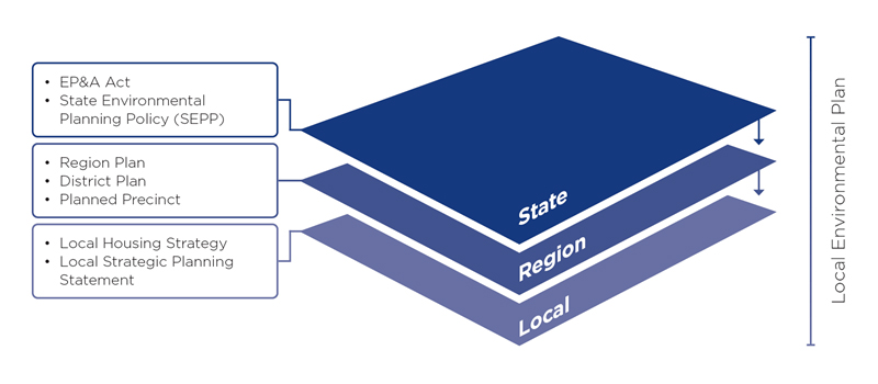
State plans
Regional plans are state-led strategic planning documents that set the direction and establish objectives to deliver a liveable productive, and sustainable planning framework in NSW.
Learn more about regional plans.
Five district plans implement the vision and objectives of the Greater Sydney Region Plan at a district level.
These 20-year plans provide a bridge between regional and local planning to inform LEPs, local strategic planning statements (LSPS), community strategic plans and the assessment of planning proposals.
Precincts provide a placed based strategic planning approach to growth in Sydney and set specific actions and objectives for specific areas, based on the vision outlined in the region or district plan.
Precincts provide a coordinated approach by state and local government to help ensure infrastructure such as schools, parks, community facilities, public transport and road upgrades are delivered in line with increased housing and jobs to support community needs.
Learn more about a new approach to precincts.
There are a number of other strategic planning documents including the Greater Newcastle Metropolitan Plan 2036 and special activation precincts in regional NSW. These documents set out strategies and actions for a particular LGA or precinct to create jobs, attract businesses and investors, support local industries and fuel economic development.
Learn more about:
Local plans
A Local Strategic Planning Statement (LSPS) sets out the strategic planning ambitions for a LGA as a whole and for specific areas. The LSPS allows councils to translate their strategic planning into local priorities and actions and identifies the need for further local strategic planning work.
Learn more about strategic planning from the updated Environmental Planning and Assessment Act 1979.
The LSPS Guideline for Councils (PDF, 2.6 MB) provides information for councils, the community, and other stakeholders on the contents of a LSPS, how it is made and how it is implemented.
Local housing strategies are detailed strategic and implementation plans that show where and how new homes are best developed in each local government area.
Learn more about local housing strategies.
The local housing strategy guideline provides a step-by-step process for producing local housing strategies.
Local council strategies that are endorsed, in full or part, by us may be used:
- to demonstrate the strategic merit of planning proposals;
- by planning panels or the Independent Planning Commission to determine whether a planning proposal being considered for a rezoning review has strategic merit;
- by the planning proposal authority to justify inconsistency with certain section 9.1(2) Local Planning Directions.
Endorsed local council strategies are listed below for each region, and endorsement letters are attached. Only the version of the strategy at the time of endorsement is considered endorsed not subsequent amendments.
Sydney Metropolitan
| LGA | Name of strategy | Date endorsed |
|---|---|---|
| Northern Beaches | Warriewood Valley Strategic Review 2013 (PDF, 83 KB) | 01/05/2013 |
| Willoughby | Chatswood CBD Planning and Urban Design Strategy (PDF, 1.7 MB) | 09/08/2019 |
| Willoughby | Chatswood CBD Planning and Urban Design Strategy (PDF, 98 KB) | 09/07/2020 |
Northern Region
Western Region
Southern Region
Hunter and Central Coast Region
Policy and ministerial directions
State environmental planning policies (SEPPs) are instruments that address planning issues on a state-wide level. This is different to a LEP which addresses planning controls for a local government area.
Planning proposals must provide an assessment against the relevant SEPPs and advise on how a proposal may satisfy the requirements of a SEPP.
The current list of SEPPs is located at NSW legislation.
The section 9.1 Ministerial Direction – Local Plan Making must be complied with when preparing a planning proposal, unless a specific justification for inconsistency is provided and accepted.
- Section 9.1 Ministerial Direction – Local Plan Making (2026) (PDF, 5.3 MB): Applies to planning proposals lodged on or after 1 July 2026
- Section 9.1 Ministerial Directions (last updated 2024) (PDF, 691 KB): For reference and applies to planning proposals lodged before 1 July 2026
In July 2026, a revised Section 9.1 Ministerial Direction – Local Plan Making was introduced to ensure the planning system is clear, consistent and fit for purpose. Further information is available in the guidance improvements fact sheet (PDF, 156 KB).
Guidelines
The primary guide to the LEP making process, covering how to prepare a planning proposal, engage government agencies and progress through Gateway determination and finalisation.
This guideline is module-based so it's easier to understand requirements and move between stages.
- Local Environmental Plan Making Guideline (2026) (PDF, 4.5 MB): Applies to planning proposals lodged on or after 1 July 2026.
- Local Environmental Plan Making Guideline (2023) (PDF, 4.7 MB): For reference and applies to planning proposals lodged before 1 July 2026.
In July 2026, an updated LEP Making Guideline was introduced to provide clearer and more consistent requirements, aligned with current legislation, policy settings and strategic planning priorities. Further information is available in the guidance improvements fact sheet (PDF, 156 KB).
The NSW Government is ramping up its efforts to get more people into homes sooner, releasing the 23A Guidelines on the withdrawal of Development Applications (PDF, 670 KB) for councils.
The guidelines help address the state’s housing shortfall and ensure the DA process is not holding up the potential pipeline of housing projects across NSW.
Resources
- Legislation NSW Standard Instrument Principal — Local Environmental Plan
- Standard Instrument — Local Environmental Plan (ZIP, 516 KB)
- Legislation NSW Standard Instrument (Local Environmental Plans) Order 2006
- Planning circular PS 11–011 Amendment to the Standard Instrument (Local Environmental Plans) Order 2006 (PDF, 534 KB) issued 10 March 2011
- Follow-up Review of 2022 Audit of Councils’ use of clause 4.6 – March 2023 (PDF, 431 KB)
- 2022 Audit Report – Councils’ use of clause 4.6 of the Standard Instrument – November 2022 (PDF, 627 KB)
- 2020 Audit Report – Councils’ use of clause 4.6 of the Standard Instrument – August 2021 (PDF, 599 KB)
- 2020 Report on the audit of council use of SEPP1/clause 4.6 – August 2021 (PDF, 593 KB)
- Environmental Planning and Assessment Regulation 2000 assumed concurrence notice (PDF, 69 KB)
- Varying development standards: A Guide – November 2023
- Report on the follow-up of 2016 audit recommendations – July 2019 (PDF, 276 KB)
- 2016 Report on the audit of council use of SEPP1/clause 4.6 – November 2017 (PDF, 30 KB)
All planning proposals and draft LEPs must comply with State law regarding reportable political donations. For more details, including a disclosure form, refer to:
Planning circulars provide non-statutory advice on NSW Government principles, procedures and practices to assist in implementing relevant planning laws and policies. They are updated as legislation and policy change.
In July 2026, updates were made to planning circular guidance to ensure clarity, consistency and ease of use. Further information is available in the guidance improvements fact sheet (PDF, 156 KB).
Planning practice notes provide updated commentary, guidance, and advice for planning matters generally related to principle local environmental plans and the Standard Instrument. A practice note is for information purposes only and does not comprise legal advice.
- PN 22-002 Local environmental plan zone objectives (PDF, 183 KB) replaces LEP PN 09-005
- PN 22-001 Requesting that the Minister facilitate the preparation of a local environmental plan (PDF, 101 KB) replaces LEP PN 09-004
- PN 16–001 Classification and reclassification of public land through a local environmental plan (PDF, 95 KB) replaces LEP PN 09–003
- PN 11–003 Preparing LEPs using the Standard Instrument: Standard Definitions (PDF, 615 KB)
- PN 11–002 Preparing LEPs using the Standard Instrument: Standard Zones (PDF, 104 KB) replaces LEP PN 06–002
- PN 10–001 Zoning for Infrastructure in LEPs (PDF, 292 KB)
- PN 09–006 Providing for tourism in Standard Instrument local environmental plans (PDF, 181 KB)
- PN 09–002 Environment Protection Zones (PDF, 95 KB)
- PN 09–001 Exempt and complying development (PDF, 43 KB)
- PN 08–001 Height and floor space ratio (PDF, 85 KB)
Archived LEP practice notes
- Council/department request for authority or agency feedback and advice template (DOTX/ZIP, 175 KB)
- Concise project plan template (DOCX, 65 KB)
- Cost management tool (XLSX, 41 KB)
- Dashboard reporting tool (DOCX, 64 KB)
- Letter template (DOTX/ZIP, 52 KB)
- Programming tool (MS Excel version) (XLSX, 37 KB)
- Programming tool (MS Project version) (MPP/ZIP, 374 KB)
- Project scoping tool (DOCX, 34 KB)
- Resource management tool (XLSX, 34 KB)
- Response to submissions – landscape (DOTX/ZIP, 170 KB)
- Response to submissions – portrait (DOTX/ZIP, 167 KB)
- Risk management tool (XLSX, 87 KB)
- Section 3.22 Environmental Planning and Assessment Act submission form (DOCX, 142 KB)
- Scoping proposal template (DOCX, 6.9 MB)
- Stakeholder management tool (XLSX, 42 KB)
In 2015, we developed revised standard technical requirements for spatial datasets and maps contained within planning instruments and other plans.
The standard technical requirements cover LEPs, SEPPs, development control plans and contributions plans.
The revised requirements updated and consolidated previous requirements and guidance. Previous requirements can be sourced by contacting [email protected]
Councils need to prepare spatial data and maps as per the specified standards and submit to us at draft and final stages via the online submission system for planning data available on the NSW Planning Portal.
Our continuous quality assurance program involves working with councils to ensure that the planning data submitted as part of the plan-making process meets the adopted standard.
Read the Standard Technical Requirements for Spatial Datasets and Maps (PDF, 1.8 MB) document.
For more information read the Planning Circular PS 15-005 – Commencement of the NSW Planning Portal (PDF, 72 KB).
Access the NSW Planning Portal and the Online Submission System for Planning Data.
The Parliamentary Counsel's Office (PCO) has issued advice regarding the drafting and notification processes for making delegated plans, which can be found at PCO – Information. PCO also has resources to assist in the drafting process, which can be found at PCO – Resources.
Additional provisions (commonly referred to as ‘local provisions’ or ’model local clauses’) are local clauses that have been settled by the Parliamentary Counsel’s Office that address common topics raised by councils in their standard instrument LEP preparation. The use of settled clauses reduces the time required to amend a standard instrument LEP.
Where councils would like to use one or more of the examples provided but wish to make some minor alterations to suit their specific circumstances, these may be considered with the appropriate justification, although we recommend that they be adopted 'as is' wherever possible.
For further information please contact your relevant place or regional team.
The land use matrix (XLSX, 177 KB) is an Excel spreadsheet that identifies standard land use terms, standard zones and permissibility. It has been prepared by the department to assist councils with the preparation of local environmental plans consistent with the Standard Instrument (Local Environmental Plans) Order 2006. The matrix also includes permissible land uses under a number of state environmental planning policies.
Councils can complete the matrix of intended permitted and prohibited land uses to assist in discussions with the department about their draft plan. Instructions on how to complete the matrix are provided under the ‘Instructions’ tab of the Excel spreadsheet.
Find out more about how to use land use tables.
Important note: This information does not constitute legal advice. Users are advised to seek professional advice and refer to the relevant legislation, as necessary.
Disclaimer: While every reasonable effort has been made to ensure that this document is correct at the time of publication, the State of New South Wales, its agencies and employees, disclaim any and all liability to any person in respect of anything or the consequences of anything done or omitted to be done in reliance upon the whole or any part of this document.
The department provides regular and insightful information on demographics, forecasting and population change at Data and insights.
Councils should consider infrastructure planning early in the strategic planning process.
See the Local infrastructure contributions practice notes for policy advice, best practice guidance, examples and resources relating to contribution planning and planning agreements.